ADVANTAGES OF
LAKEMASTER
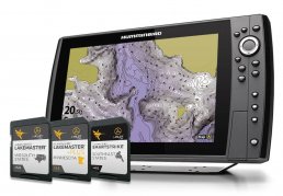
Upgrade to the unrivaled accuracy and detail of Humminbird LakeMaster lake maps. From easy-to-read contours, to highlighted depth ranges, to scrollable lake lists, you’ll have the tools you need to make the most of your limited time on the water. And with an ever-expanding list of available regions and lake maps exclusive to Humminbird owners, plus innovations like LakeMaster PLUS and SmartStrike, fish are running out of places to hide.
UNPARALLED FRESHWATER MAP DETAIL
HIGH
DEFINITION
DETAIL
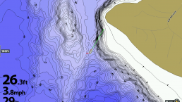
Most of our High Definition lake maps were created by our own GIS survey crew who spend tireless hours mapping year round. Their information is then processed, resulting in highly accurate 1′-3′ depth contour maps, providing anglers with detail they can’t find anywhere else.
STANDARD
DEFINITION
DETAIL
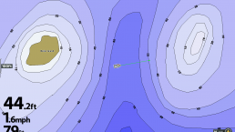
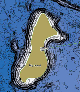
The remaining maps in our library are Standard Definition and include contours typically in 3′-5′ intervals. Humminbird LakeMaster creates these maps by using publicly available information as a basemap, then our GIS analysts apply techniques to ensure accuracy of shorelines and update visible features.
EXCLUSIVE
LAKEMASTER FEATURES
Making sense of it all just got a whole lot easier. Identify buoys, daymarkers, hazards, hotels, marinas and countless other navigation aids and points of interest with our comprehensive icon system. You’ll also see contours, depth markings and, for coastal areas, spot soundings. On the water, confidence is key. And the Humminbird Basemap delivers.
HIGHLIGHT
DEPTH
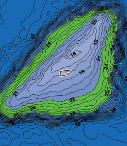
Select and highlight a particular depth range, so you can easily target productive water and stay in the bite zone.
SHALLOW WATER
HIGHLIGHT
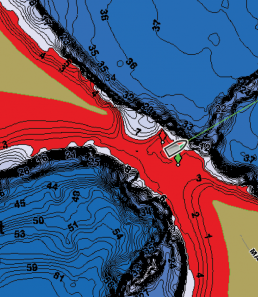
Easy-to-see shading highlights shallow water areas on an adjustable range from 0 to 30 feet, making it easier to spot flats and reefs for shallow water fishing.
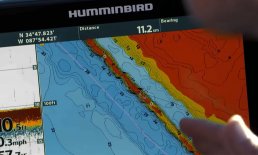
WATER LEVEL
OFFSET
Synchronize the depth contours and shorelines of your LakeMaster charts with the actual water levels of lakes, reservoirs and rivers.
The revolutionary patented features of LakeMaster maps, combined with your Humminbird fish finder and Minn Kota trolling motor will enhance your fishing experience. And that’s no fish tale.
i-PILOT LINK

LAKEMASTER PLUS
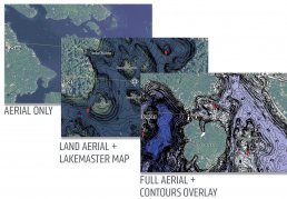
For an added angling advantage, opt for Humminbird LakeMaster PLUS. These maps include all of the features of LakeMaster with one key addition: aerial photography of high definition lakes, providing visibility to docks, buildings, and structure. You also get the choice of how you view the aerial imagery:
AERIAL ONLY – Satellite view over all land and water, no map data
LAND AERIAL + LAKEMASTER MAP – Satellite over land surrounding lake, LakeMaster map on water area
FULL AERIAL + CONTOURS OVERLAY – Satellite over land and water, contour data overlay on water