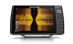
UNDERSTANDING
SIDE IMAGING
It’s all in the details. Gain a 180 degrees side-to-side perspective on the world below the surface with remarkable Humminbird® Side Imaging®. In an instant, the ultra-thin beam scans the area up to 400 feet to the left and right of your boat location – for total coverage of up to 800 feet. The return image for each slice is then added to the images taken immediately before and after to build an incredible view of the lake bottom. You can then magnify the detail of the image with the zoom feature or mark the GPS location of promising cover or structure directly on the screen.
WHATS ON YOUR SCREEN
The key to making side imaging work for you on the water is learning how to read and interpret the returns with confidence.
INTERPRETING YOUR RETURNS
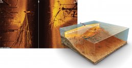
Humminbird Side Imaging sonar uses a razor-thin beam to take a “sonar snapshot” of the area up to 400 ft. to the left and right of your location. The return image for this slice is then added to the images taken immediately before and after to build an incredibly detailed view of the lake bottom.
READING THE SCREEN
The dark, center portion of the screen represents the column of water below your boat. The lighter portions on the far left and right of the screen show you the bottom below and to the left and right of your boat. Keep in mind, Side Imaging is a record of the water and terrain your boat has already passed over
THROW OUT
A 800' WIDE NET
BOTTOM AND ROCKS
Get an understanding of your bottom type by locating rocks and crevices.
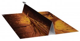
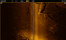
WEED BEDS
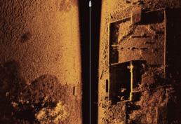
Clearly identify weed beds (lower left) along with the detailed wall of an old foundation and even the steps leading into the house.
FISH DETAIL
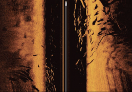
See fish so defined you can practically target each one individually.
FEATURES
THAT GET TO THE POINT
MARK WAYPOINTS
See something interesting with Side Imaging, like a school of fish over a bridge piling shown here with MEGA Side Imaging? Save its exact GPS location as a waypoint.
ZOOM
Enable the zoom mode to hone in on the tiniest details. Here, an angler has identified a school of crappie.
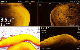
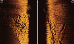
SPLIT SCREEN
View multiple Humminbird sonar and imaging technologies at once for a complete picture. Here, we can see trees, weeds, and fish to the right side of the boat as the depth falls off.
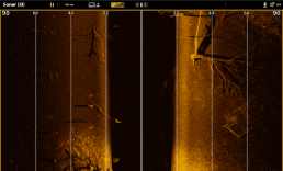
RANGE LINES
Enable range lines to help determine the distance between your boat and fish, structure or weeds. Here, we can see a large tree between 30 and 70 feet off to the right .
CONTOUR MODE
Use Contour Mode to remove the water column. Notice how you can clearly see the bottom hardness and depth transition beginning at the bottom of the screen and leading to the large tree and old building foundation.
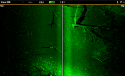
COLOR PALETTE
Choose one of twelve color palettes and adjust the sensitivity and sharpness. Customising your screen to match your water conditions will make it easier to identify structure and fish.